
A tripod shot for height perspective.

Another view...

Many Ukrainian shops lined the streets in downtown Vegreville.
Start time: 0845
Start odometer: 17171
Weather: Overcast start, bright sun soon broke through, 44 F.
Click on picture for larger image, hit back button to return to this page.
I have always wondered what this city looked like since hearing the Guess Who song Running Back to Saskatoon many years ago. (Link to lyrics) In fact, I heard the song while on the road in August! I will get a chance to explore tomorrow and see why this is called "The City of Bridges."
There were high clouds at the start of the day, but later, they began to break and I had a good amount of sunshine. This morning's temperature was 44 degrees F., and warmed up to 61 this afternoon. I also decided this morning to head towards the southeast and skip Drumheller. It will be on my list of places to return during the travel season when the attractions and museums will be open.
My first visit was to the largest Pysanka (Ukrainian Easter egg) in the world, in Vegreville, Alberta. It is 25.7 feet in length, 18.3 feet wide, and is 31 feet above the ground at its highest point. It is set atop a movable stand, so it will turn in the direction of the wind!
|
A tripod shot for height perspective. |
Another view... |
Many Ukrainian shops lined the streets in downtown Vegreville. |
While the direct route would have
been to take Route 16, I drove a side route that took me though some very pretty
rolling hills, farmland, and interesting small towns. Also, many small
ponds sloughs lined the road, and there were several large groups of birds preparing for
their fall journey. Along the road, some of the farms and ranches had a
shoe on top of each of their barbed wire fence posts! They would go on
forever, with hundreds of shoes! I recall seeing a similar scene while
driving through the north-central part of the lower forty-eight.
NOTE: Correction to the previous paragraph. As I have mentioned before, I get many e-mails from visitors to the site. I enjoy the feedback, and especially the corrections. Accuracy is important to me. With this in mind, I thank Lyndi, who was working in Indiana at the time I received the e-mail, for correcting the name of ponds. They are called sloughs in western Canada. Thank you Lyndi for the information!
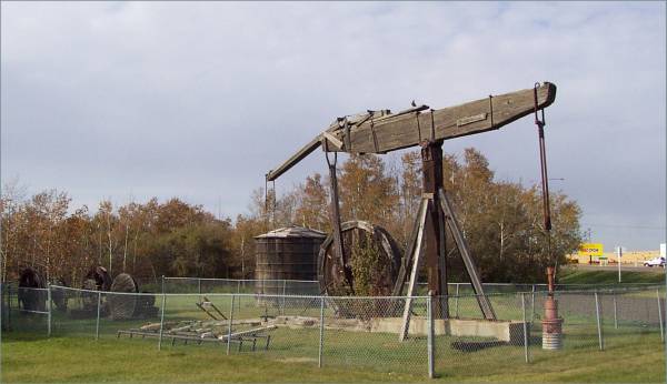
The region is also dotted with oil rigs. I stopped in the town of Wainwright, where they had part of an original drilling rig. This rig was used when hammering a hole into the ground was the method to find oil. There were informative display panels, but they suffered from a lack of upkeep, and the pigeons had left their mark! Pictures would not be legible.
|
The short story of Wainwright. |
One of the original drilling rigs. |
Back on Route 14, I was driving east when I saw a sign indicating a tourist site for the Koroluk Slide. It was twenty-one kilometers on a gravel road (my car seems to keep finding unpaved roads!) Arriving at the site, there was a small stand with some information describing the landslide. However, the amount of moved earth was very large. It was remarkable to see how much of had shifted.
|
The road to the site. |
The story of the slide. |
Looking towards the north. |
|
Looking southward, you can see the continuation of the road in the upper right of the picture. |
The "Visitor's Center!" And yes, there was a guest book, and I signed it! |
Returning to Route 14, I soon entered Saskatchewan! I believe this is the first time I have been here, which makes for my ninth province! This also brings me back into the Central Time zone, though I later learned that this province does not participate in Daylight Savings Time.
About seventy-five kilometers later, I arrived in the town of Cut Knife. According to the AAA guide, this was the location of several Indian uprisings. This is also the location of the world's largest tomahawk! The handle is fifty-four feet long and weighs six tons! The blade is made of fiberglass and weighs 2750 pounds! For my friends Tom, Chris, and Norm in Maine, we could use this with the fly rod from October 4!
|
A new province for me. |
I am standing just to the left of the Teepee. The tomahawk is located in Tomahawk Park (good place for it!) |
The HUGE blade! Notice the pretty sky! |
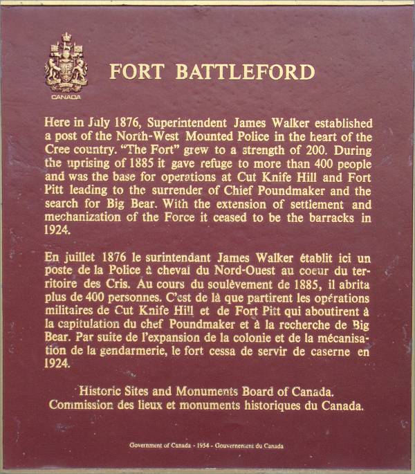
I rejoined Route 16 in Battleford, Saskatchewan, and stopped by Fort Battleford just south of the town. Unfortunately, it was not open, but the plaque gives a short description of the fort.
|
|
|
Finally, I arrived in Saskatoon, and the road happened to go by the airport, so....
 The entrance to Saskatoon International Airport (YXE) |
 The terminal and FCC tower. |
I decided to stop a bit early for the day at a motel just south of town, since it was time to wash the laundry. Tomorrow I plan on exploring Saskatoon in the morning, then I should be back in the United States sometime in the afternoon. Plans are to stop near the Theodore Roosevelt National Memorial Park in North Dakota. Of course, with the wonderful way I can travel, I could be somewhere else!
Thank you for reading the page. Please let me know what you think!
Routes traveled today: Ca 16a - Ca 16 - Ab 36 - Ab 14 - Saskatchewan 40 - Ca 16 - Ca 11
Hotel: Travel Inn Motel -

This page
accessed
times.
Page created by: igorn@igorn.com
Copyright © 2001 Igor N. Nikishin
All Rights Reserved
Pictures may be used with permission.


